PRESS RELEASE
Issued by: Vexcel Imaging GmbH
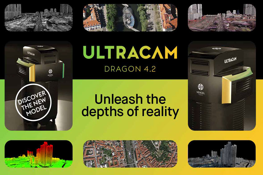
Photo: Vexcel Imaging
Vexcel Imaging proudly announces the launch of the UltraCam Dragon 4.2, the next evolution in hybrid aerial mapping technology. Building on the success of its predecessor, the new system features a significantly larger nadir and oblique image footprint, delivering a performance boost with 35% more flight line efficiency for faster data collection. Its powerful sensor suite combines two nadir cameras (RGB and NIR) and four high-resolution oblique RGB cameras (19,136 x 12,736 pixels each), with a 2.4 MHz RIEGL Waveform LiDAR scanner, delivering unmatched productivity, precision, and comprehensive ground coverage.
“We’re especially proud to announce that the very first UltraCam Dragon 4.2 worldwide will be sold right here at Intergeo to our valued customer Slagboom & Peeters Aerial Surveys,” says Alexander Wiechert, CEO of Vexcel Imaging. “The UltraCam Dragon is more powerful and efficient than ever and is ready to unlock new possibilities in the toughest environments, outperforming in applications from 3D city modeling to vegetation analysis.”
Vexcel Imaging leads the way as the first aerial system manufacturer to adopt Sony’s cutting-edge IMX811 CMOS sensors, featuring 247 megapixels and a 2.81 µm pixel size, across its system lineup. In 2025 alone, the company unveiled three new systems: the UltraCam Osprey 4.2 in spring and the UltraCam Dragon 4.2 and UltraCam Merlin 5.0 at Intergeo, marking a notable expansion of its portfolio within a single year. This rapid sensor integration was made possible through Vexcel’s proprietary lens design and the sophisticated True Pixel Processing (TPP) pipeline within UltraMap, ensuring the UltraCam systems continue to deliver the industry-leading image quality they are renowned for.
The integrated RIEGL VQ-680 Waveform LiDAR scanner features an innovative multi-axis scan geometry with five distinct viewing angles (−20°, −10°, 0°, +10°, +20°) across a 60° field of view, including a true nadir scan line. This nadir component is crucial for achieving comprehensive coverage in narrow urban canyons and dense environments. The linear scan pattern delivers uniform ground coverage, ensuring consistent and balanced point distribution along the flight path. The varied viewing angles enable detailed capture of vertical structures such as building facades and significantly improve vegetation penetration, making the system ideal for both urban and natural landscapes.
The UltraCam Dragon 4.2 delivers exceptional image quality by adhering to sound photogrammetric principles and leveraging Vexcel Imaging’s True Pixel Processing (TPP) pipeline, which preserves all pixel information from capture to final product. At its core is Adaptive Motion Compensation (AMC), a proprietary software-based technology that automatically corrects for complex, multi-directional motion blur, ensuring sharp, accurate imagery across the entire project in a scene-aware manner. Combined with precise LiDAR alignment, flexible operating modes, 2 focal length options (50 mm and 80 mm), and seamless integration into the Vexcel ecosystem, the Dragon 4.2 streamlines workflows and maximizes operational efficiency and value for users and their data.
The new UltraCam Dragon 4.2 is available for purchase.
Key Specifications
Camera
- 19,136 x 12,736 pixels nadir (RGB Bayer pattern & NIR) and oblique (RGB Bayer pattern)
- Sony IMX811 CMOS imaging sensors
- 2 focal length options (50 mm and 80 mm)
- 1 frame per 0.7 seconds
- True Pixel Processing (TPP)
- Adaptive Motion Compensation (AMC)
LiDAR Scanner
- High pulse repetition rates of up to 2.4 MHz
- Nadir, forward and backward scan line directions at 0, ±10, ±20 degrees along track
- Wide field of view of 60 degrees across track
- Multiple target capability
| Contact details from our directory: | |
| Vexcel Imaging GmbH | Cameras (Airborne), Camera Mounts |
| RIEGL Laser Measurement Systems GmbH | Laser Altimeters, Cameras (Airborne), Laser Positioning Equipment, Sensors/Transducers, Distance Measuring Equipment, Multi-Spectral Imaging Systems |
| Related directory sectors: |
| Imaging and Visual Systems |

Weekly news by email:
See the latest Bulletin, and sign up free‑of‑charge for future editions.
CubCrafters offers Garmin AXIS across entire lineup
Collins in Wolverhampton begins testing electric actuation
Cirrus TRAC10 trainer gains dual touchscreen flight deck
Electra’s EL9 ultra-short hybrid advances toward certification