PRESS RELEASE
Issued by: Garmin International
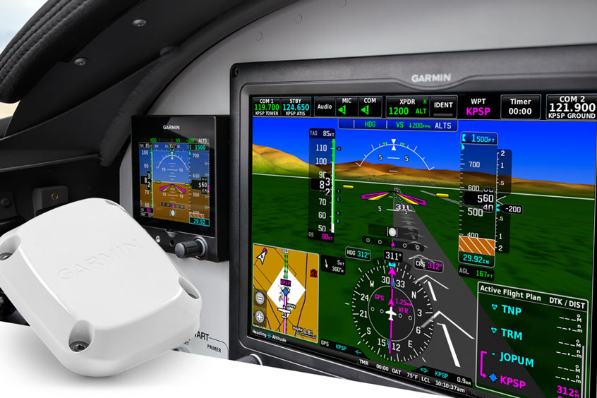
Photo: Garmin
Garmin today announced GHA 15, a small and lightweight height advisor that uses radar technology to provide height above ground level (AGL) information on G3X Touch™ flight displays for experimental aircraft. This cost-effective, easy-to-install solution is available immediately for experimental aircraft and light sport aircraft.
The GHA 15 calculates height AGL by sending radio waves to the ground and determining the time it takes to receive the signals back. GHA 15 processes hundreds of measurements per second and applies advanced digital filters to maintain continuous readings – even over water or in challenging terrain environments. AGL readouts are shown on the G3X Touch display and drawn on the altitude tape or gauge at altitudes as high as 500 feet AGL.
Using the readings provided by GHA 15, G3X Touch flight displays can also provide AGL audio callouts via their audio output to help keep the pilot's eyes looking outside the cockpit. Beginning at 300 feet, the pilot will hear audible AGL altitude callouts at select intervals down to 1 foot AGL. The pilot can configure the callouts to start and stop at specified altitudes. Knowing precise height AGL can be helpful to pilots during landings and flying in areas where limited barometric altimeter setting information is available – such as backcountry flying.
The single module integrates all electronics into one compact unit that attaches to the bottom of the aircraft. Slightly larger than a deck of cards and weighing less than one pound, the height advisor requires minimal space and modification for installation on the aircraft.
The GHA 15 is available immediately for an expected street price of $1,995. For additional information, visit Garmin.com/GHA15.
| Contact details from our directory: | |
| Garmin International | GPS, Transceivers, Radar Transponders, Position Indicators, Radio Communications Equipment, Instrument Landing Systems, Moving Maps, Flight Directors, Electronic Flight Instrument Systems, Flight Management Systems, Avionics Management Systems, Autopilots, Weather Mapping Radar, VOR (Omnirange) Receivers, Onboard Intercom Systems, Collision Avoidance Systems/TCAS, Radar/Radio Altimeters, Attitude and Heading Reference Systems, Magnetometers, Onboard Computers, Air Data Computers, Satellite Receivers, Automatic Flight Control Systems, Onboard Airport Navigation Systems, Terrain Awareness and Warning Systems, Head-Up Displays, Airborne Communication Systems, Engine Indicator Instruments, Storm-Warning Radar, Autothrottle Systems, ADS-B systems |
| Related directory sectors: |
| Sensors, Transducers & Detectors |
| Imaging and Visual Systems |
| Air Data & Flight Instruments |

Weekly news by email:
See the latest Bulletin, and sign up free‑of‑charge for future editions.

CubCrafters offers Garmin AXIS across entire lineup

Collins in Wolverhampton begins testing electric actuation
Cirrus TRAC10 trainer gains dual touchscreen flight deck

Electra’s EL9 ultra-short hybrid advances toward certification