PRESS RELEASE
Issued by: Garmin International
Garmin International, Inc., a unit of Garmin Ltd., today announced a revolution in general aviation - the first Garmin Autoland system. In the event of an emergency, Autoland will control and land the aircraft without human intervention. The Autoland system determines the most optimal airport and runway, taking into account factors such as weather, terrain, obstacles and aircraft performance statistics. Autoland brings peace of mind to air travel and will soon be available on select general aviation aircraft with the Garmin G3000 integrated flight deck.
"Today, aviation is forever changed as we introduce one of the industry's most significant innovations – the first Autoland system for general aviation aircraft," said Cliff Pemble, Garmin president and CEO. "The unveiling of Autoland demonstrates Garmin's deep commitment to develop advanced technologies that enhance aviation safety and save lives."
In the event of an emergency, the pilot or passengers on board the aircraft can activate Autoland to land the aircraft with a simple press of a dedicated button. Autoland can also activate automatically if the system determines it's necessary. Once activated, the system calculates a flight plan to the most suitable airport, initiates an approach to the runway and automatically lands the aircraft – without pilot or passenger intervention.
"The vision and development of the world's first Autoland system for general aviation was a natural progression for Garmin as we looked at our aircraft systems and existing autonomous technologies and recognized it is our responsibility to use these building blocks to deliver a technology that will change lives and revolutionize air travel," said Phil Straub, Garmin executive vice president and managing director of aviation. "Congratulations to the entire Garmin team for executing upon a tremendous vision that will transform the industry, forever change lives and help protect the most valuable contents in and around the aircraft – our children, family and friends."
During an Autoland activation, the system takes into account a breadth of information and criteria. Factors taken into consideration when identifying the most suitable airport include weather, fuel on board, runway surface and length, terrain, obstacles and more. The availability of a GPS approach with lateral and vertical guidance to the runway is also required when the system is considering various airports and runways. Even further, the system will automatically communicate with air traffic control (ATC), advising controllers and pilots operating near the aircraft of its location and its intentions.
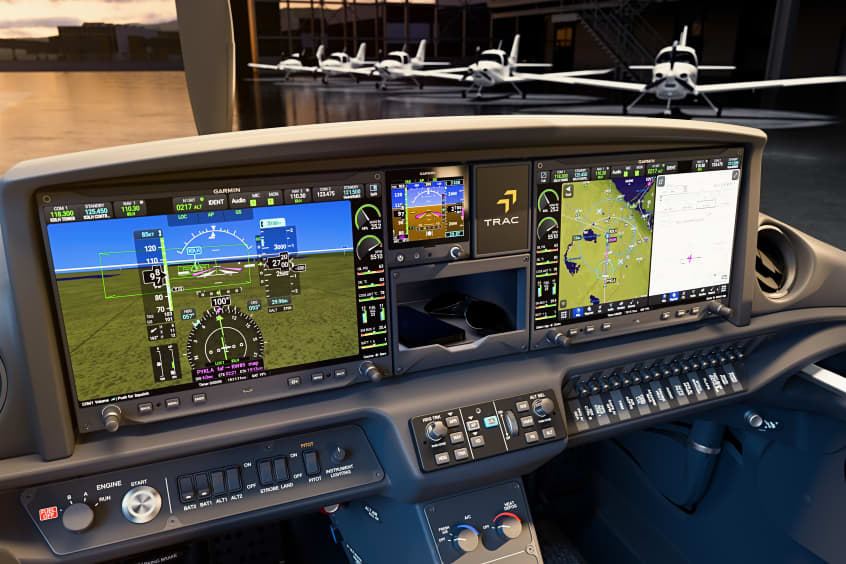
Throughout an Autoland activation, the system provides simple visual and verbal communications in plain-language so passengers in the aircraft know what to expect. The flight displays show the aircraft's location on a map alongside information such as the destination airport, estimated time of arrival, distance to the destination airport and fuel remaining. Airspeed, altitude and aircraft heading are also labeled in an easy-to-understand format. Passengers also have the option to communicate with ATC by following instructions on the display using the touchscreen interface on the flight deck.
The Garmin Autothrottle system is used to automatically manage aircraft speed, engine performance and engine power so the aircraft can climb, descend or maintain altitude as needed during an Autoland activation. On approach to land, the system initiates a controlled descent to the airport. If the aircraft needs additional time to descend or slow down during the approach, the Autoland system initiates a standard holding procedure and extends the landing gear and flaps. Once in landing configuration, the aircraft begins its descent to the runway. On the runway, automatic braking is applied while tracking the runway centerline to bring the aircraft to a full stop. Engine shutdown is also automated so occupants can safely exit the aircraft.
At any time, a pilot can easily deactivate an Autoland activation. With a single press of the "AP" autopilot key on the autopilot controller or the autopilot disconnect button on the controls, an Autoland activation can be canceled. The flight display shows a message that confirms Autoland has been deactivated and in the event of an accidental deactivation, the system shows passengers how to reactivate Autoland if needed.
Garmin Autonomi, a family of automated flight technologies, encompasses Autoland, Emergency Descent Mode (EDM) and Electronic Stability and Protection (ESP). These technologies add to the safety enhancing tools and capabilities of a Garmin-equipped flight deck. For example, in the event an aircraft loses pressurization, EDM is capable of automatically descending the aircraft to a preset altitude without pilot intervention to help avert hypoxic situations.
ESP further enhances the Autonomi suite by working to assist the pilot in avoiding unintentional flight attitudes beyond that for normal flight. ESP works in the background while the pilot is hand flying the aircraft to help pilots avoid inadvertent flight attitudes or bank angles. Should the pilot become inattentive while hand-flying the aircraft and exceed pre-determined pitch, roll or airspeed limitations, Garmin ESP activates and the pilot will feel pressure on the flight controls that guide him/her back to a recommended flight limit.
Autoland will soon be available as part of the G3000 integrated flight deck on the Cirrus Vision Jet and the Piper M600, pending Federal Aviation Administration (FAA) certification.
| Contact details from our directory: | |
| Garmin International | GPS, Transceivers, Radar Transponders, Position Indicators, Radio Communications Equipment, Instrument Landing Systems, Moving Maps, Flight Directors, Electronic Flight Instrument Systems, Flight Management Systems, Avionics Management Systems, Autopilots, Weather Mapping Radar, VOR (Omnirange) Receivers, Onboard Intercom Systems, Collision Avoidance Systems/TCAS, Radar/Radio Altimeters, Attitude and Heading Reference Systems, Magnetometers, Onboard Computers, Air Data Computers, Satellite Receivers, Automatic Flight Control Systems, Onboard Airport Navigation Systems, Terrain Awareness and Warning Systems, Head-Up Displays, Airborne Communication Systems, Engine Indicator Instruments, Storm-Warning Radar, Autothrottle Systems, ADS-B systems |
| Related aircraft programs: |
| Piper M500/M700 Fury |
| Cirrus Vision SF50 |
| Related directory sectors: |
| Landing Guidance Systems |

Weekly news by email:
See the latest Bulletin, and sign up free‑of‑charge for future editions.

CubCrafters offers Garmin AXIS across entire lineup

Collins in Wolverhampton begins testing electric actuation
Cirrus TRAC10 trainer gains dual touchscreen flight deck

Electra’s EL9 ultra-short hybrid advances toward certification